Beyond the Forecast: Spectacular Weather Events Caught on Camera
Join us we embark on a journey through the world of astonishing weather phenomena. From the awe-inspiring dance of the Northern Lights to the dramatic fury of tornadoes, nature's wonders never cease to amaze. In this series, we'll explore 40 remarkable weather events that have been caught on film, revealing the stunning beauty and power of our planet's atmosphere. Each phenomenon offers a glimpse into the fascinating forces at play in our skies, from ethereal fogbows to the explosive brilliance of volcanic lightning. Get ready to be both educated and entertained as we unravel the mysteries of weather and delve into the breathtaking moments that remind us of the Earth's incredible dynamism. So, let's embark on this meteorological adventure and discover the astonishing weather phenomena that continue to captivate and inspire us all.
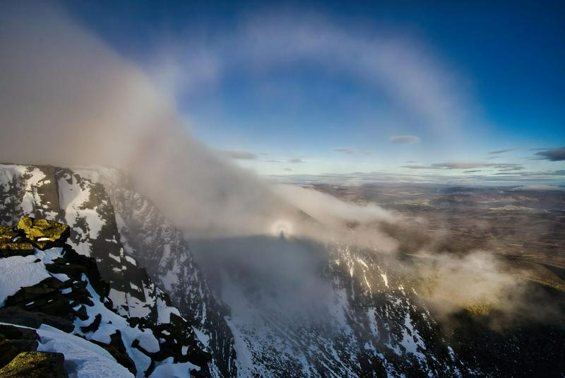 The Brocken Spectre, a captivating optical illusion that occurs when an observer casts a shadow onto a bank of fog or mist, often seen atop a mountain or high ridge. This phenomenon creates the illusion of a gigantic, elongated shadow with a halo of colored rings surrounding it. The name "Brocken Spectre" originates from the Brocken, a peak in the Harz Mountains of Germany, where this phenomenon was first documented. It happens when sunlight is diffracted or scattered by water droplets in the mist, creating a stunning and often eerie visual spectacle that has fascinated mountaineers and explorers for centuries.
 Polar Stratospheric Clouds
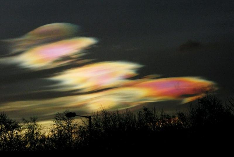 Polar stratospheric clouds, also known as "nacreous clouds" or "mother-of-pearl clouds," are a rare event that occurs in the Earth's stratosphere, typically at high latitudes near the polar regions. These clouds are distinguished by their vibrant and iridescent colors, ranging from pinks and purples to greens and blues, which result from the scattering of sunlight by tiny ice crystals or supercooled water droplets within the clouds.
Polar stratospheric clouds form during the frigid winter months when temperatures in the stratosphere drop to extremely low levels. These cold conditions enable the formation of ice crystals or supercooled water droplets, which are not typical in the stratosphere under normal circumstances. Their iridescent colors and unique appearance make polar stratospheric clouds a captivating and rare sight in the sky, and they have significant implications for the chemical processes that lead to ozone depletion in the polar regions.
Parhelion

A parhelion, also known as a "sun dog" or "mock sun," is an optical phenomenon that creates the appearance of one or more bright spots of light on either side of the sun, often forming a halo-like effect. Parhelia occur due to the refraction, or bending, of sunlight by hexagonal ice crystals in cirrus or cirrostratus clouds. These ice crystals align themselves horizontally as they fall through the atmosphere, refracting sunlight and creating the illusion of additional suns.
Parhelia are typically seen when the sun is low on the horizon, such as during sunrise or sunset. They are often accompanied by a 22-degree halo, which encircles the sun, adding to the visual spectacle.
Fog

Fog is characterized by the presence of low-lying clouds composed of tiny water droplets suspended in the air, reducing visibility near the Earth's surface. It occurs when air near the ground cools to the point where it cannot hold its moisture in vapor form, causing water droplets to condense into suspended water droplets or ice crystals. Fog can vary in density from light mist to thick blankets, and it can form in various settings, including coastal areas, valleys, and urban environments. This atmospheric condition can impact transportation, create eerie and serene landscapes, and is essential for some ecosystems as a water source.
Squall Line
A squall line is a well-organized and often intense line of thunderstorms that can stretch for hundreds of miles and produce severe weather conditions. These weather systems typically form along or ahead of a cold front, where warm, moist air meets cooler, drier air. Squall lines are characterized by a distinct, linear cloud formation with a solid line of towering cumulonimbus clouds.
Squall lines can bring a range of severe weather phenomena, including heavy rainfall, intense lightning, hail, strong winds, and even tornadoes. The line moves rapidly, and the associated weather can be intense and hazardous. They are known for their ability to generate widespread and damaging weather impacts, making them a focus of attention for meteorologists and weather-watchers.
Crepuscular rays
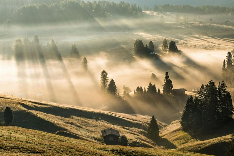
Crepuscular rays, often called "God rays," are a breathtaking natural event that occurs when sunlight streams through openings in clouds or other obstructions in the atmosphere. These rays appear as bright, well-defined beams of sunlight that radiate outward from the source, creating a captivating and almost mystical appearance. Crepuscular rays are most commonly observed during sunrise or sunset when the sun is low on the horizon, and the interplay of light and shadow is at its most dramatic. These rays can stretch across the sky, seeming to converge at the point in the sky where the sun is located, and they often leave onlookers in awe of the beauty of the natural world.
Aurora
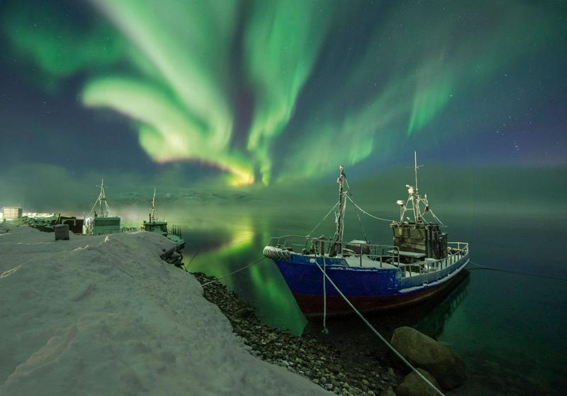
The Aurora, also known as the Northern and Southern Lights, is a mesmerizing natural light display that occurs predominantly in high-latitude regions near the Earth's magnetic poles. This stunning phenomenon is caused by the interaction between charged particles from the sun and the Earth's magnetic field. When these charged particles collide with gases in the atmosphere, such as oxygen and nitrogen, they produce a colorful spectacle of shimmering lights. The Northern Lights are seen in the Northern Hemisphere, while the Southern Lights grace the skies in the Southern Hemisphere. These ethereal curtains of light, ranging from green to pink and even purple, create a celestial ballet that has captivated observers for centuries.
Lightning Sprites
Lightning sprites are fascinating and elusive electrical phenomena that occur high above thunderstorms. These ethereal events take place in the Earth's mesosphere, typically at altitudes of 30 to 50 miles (50 to 80 kilometers), and they are associated with intense lightning storms. Lightning sprites are brief, bright flashes of light that can take various forms, including tendrils, columns, or jellyfish-like shapes.
These phenomena are triggered by the powerful electrical discharges that originate from thunderstorms and extend upward into the mesosphere. Lightning sprites occur in response to the intense electrical fields created by thunderstorms, and they are often faint and difficult to observe from the ground. However, they have been captured in photographs and videos taken from aircraft and high-altitude balloons. Lightning sprites are still a relatively new area of scientific research, and their exact mechanisms and significance in atmospheric science are still being studied.
Air Discharge

Air discharges, often referred to as lightning, are a spectacular and powerful weather phenomenon. Lightning is a sudden electrostatic discharge that occurs within a thundercloud or between a cloud and the Earth's surface. It results from the buildup of electrical charges within clouds, which are eventually released in the form of a bright, branching bolt of electricity. The intense heat generated by lightning causes the surrounding air to rapidly expand and create a shockwave, leading to the booming sound we hear as thunder. Lightning strikes can be destructive, sparking wildfires, damaging buildings, and even posing risks to human safety, making them both awe-inspiring and potentially hazardous natural occurrences.
Jacob's Ladder

Jacob's Ladder is a mesmerizing atmospheric phenomenon that occurs when sunlight interacts with ice crystals in the air. This creates a stunning optical display, consisting of a series of bright and colorful vertical streaks or rays extending upward from the sun. These rays are typically reddish or yellowish near the sun, transitioning to blue and green as they extend farther from the solar disk. Jacob's Ladder is a type of sun pillar, and its name originates from the biblical story of Jacob's dream of a ladder extending into the heavens. It's a rare and beautiful sight, often observed in cold climates where ice crystals are present in the atmosphere, and it adds a touch of celestial magic to the sky.
Derechos

Derechos are intense and widespread windstorms characterized by a long-lived line of severe thunderstorms. These formidable weather events are known for their damaging straight-line winds that can reach hurricane force, along with heavy rainfall, large hail, and sometimes even tornadoes. Derechos typically develop in warm and unstable air masses, often in the summer months, and can travel hundreds of miles, leaving a path of destruction in their wake. The term "derecho" is of Spanish origin, meaning "straight ahead" or "direct," emphasizing the straight-line nature of the damaging winds associated with these severe storm systems. Derechos can cause significant property damage, power outages, and pose serious risks to public safety.
Double Rainbow

A double rainbow is a captivating anomaly that occurs when sunlight is refracted, or bent, as it passes through raindrops in the atmosphere. This refraction causes the sunlight to separate into its various colors, creating the primary rainbow we commonly see. A double rainbow occurs when the sunlight is both refracted and internally reflected inside the raindrops before exiting, creating a secondary and fainter rainbow that appears just outside the primary one. The primary rainbow displays the colors in the sequence of red on the outer edge and violet on the inner edge, while the secondary rainbow reverses this order. Double rainbows are a rare and beautiful sight, often with the secondary rainbow appearing farther from the primary one and displaying its colors with greater pastel hues. They are a stunning reminder of the magical interplay of light and water droplets in the sky.
Earth Shadow

The Earth Shadow, also known as the "Belt of Venus" or "antitwilight arch," can be observed during twilight, either at sunrise or sunset. This phenomenon occurs as the Earth's shadow is cast onto the atmosphere in the opposite direction of the sun, creating a distinctive band of bluish-gray or pinkish-purple coloration just above the horizon.
The Earth Shadow is caused by the scattering of sunlight in the Earth's atmosphere. As the sun sinks below the horizon, its direct rays no longer illuminate the sky, but the remaining scattered sunlight continues to light up the atmosphere above. This phenomenon is often enhanced by the presence of dust, haze, or other particles in the atmosphere, which scatter the sunlight and create the visually stunning colors. The Belt of Venus can be a captivating and serene sight, adding a touch of natural beauty to the beginning or end of the day.
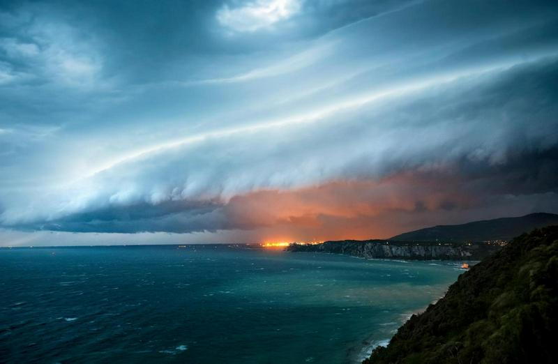
Arcus Clouds

Arcus clouds, also known as "roll clouds" or "shelf clouds," are unique cloud formations often associated with severe weather, particularly thunderstorms. These low, horizontal clouds stretch across the sky for miles and come in two main types: shelf clouds and roll clouds. Shelf clouds have a wedge-like appearance and form at the leading edge of thunderstorms, while roll clouds are cylindrical and detached from storms, resulting from horizontal rolling air motion. Both types can bring strong winds, heavy rain, and turbulence, serving as indicators of approaching severe weather. Despite their intimidating appearance, arcus clouds also offer a captivating display of nature's power and beauty.
Volcanic Lightning

Volcanic lightning, also known as "dirty thunderstorms," is a striking natural occurrence observed during volcanic eruptions. It involves impressive lightning flashes within the volcanic plume or ash cloud. While the exact mechanism is not fully understood, it is believed to result from the collision and separation of ash particles and rock fragments within the eruption plume, generating static electricity that discharges as lightning. These displays are often associated with explosive eruptions, illustrating the immense energy and hazards linked to volcanic events, such as ashfall, pyroclastic flows, and lava flows.
Fogbow

A fogbow is a captivating atmospheric optical phenomenon similar in appearance to a rainbow but occurring in foggy or misty conditions. It forms when sunlight interacts with tiny water droplets or ice crystals in the air, just like a traditional rainbow. However, fogbows are typically white or pale in color, with fainter outer rings, due to the smaller droplet size and lack of significant light dispersion that occurs in regular rainbows. Fogbows are often observed in coastal areas or near water bodies when fog or mist is present and sunlight breaks through, creating a subtle and ethereal circle of colors that can add a touch of magic to a foggy landscape.
Frostwork

Frostwork is a mesmerizing natural event that occurs in cold and icy environments, such as caves, when water vapor freezes and forms intricate, delicate ice formations. These formations can resemble delicate, intricate, and feathery designs, creating a stunning underground spectacle. Frostwork is often found in limestone caves where moisture-rich air interacts with the cool cave environment, causing water to freeze and slowly accumulate over time. The result is a breathtaking display of nature's artistry, with icicles and frost patterns adorning cave walls and ceilings, adding to the wonder and beauty of subterranean landscapes.
Green Flash

The green flash is a rare optical phenomenon that occurs during sunrise or sunset when a sliver of the sun's upper edge briefly appears to flash or glow green just as it touches or disappears below the horizon. This fleeting and vivid green hue results from the atmospheric bending or refraction of sunlight as it passes through the Earth's atmosphere. The green flash is most commonly seen in clear, unobstructed, and low-humidity conditions, where the sunlight's journey through the atmosphere is most pronounced. This phenomenon is a captivating and elusive sight for skywatchers, adding a touch of enchantment to the beginning or end of a day.
Fallstreak Hole

A Fallstreak Hole, also known as a hole-punch cloud, is characterized by a large, circular or elliptical gap that appears in a layer of cloud cover. This unique cloud formation occurs when supercooled water droplets in a cloud rapidly freeze or crystalize due to the introduction of ice nuclei, often from the passage of an aircraft. As the ice crystals grow, they cause a chain reaction, resulting in a localized region of cloud clearing, creating the distinct hole-punch shape. Fallstreak holes can be surrounded by wispy streaks of ice crystals and are typically observed in altocumulus or cirrocumulus clouds. These phenomena are both mysterious and visually striking, making them a fascinating spectacle for skywatchers.
Iridescent clouds

Iridescent clouds occur when sunlight interacts with tiny water droplets or ice crystals in the air. These clouds display vibrant, shimmering colors, similar to the colors of a rainbow, but in a more subtle and delicate manner. Iridescence in clouds is often seen near or around the edges of clouds, especially when the clouds are thin and composed of uniform droplets or crystals. The phenomenon is caused by the diffraction, or bending, of sunlight as it passes through these small particles, creating interference patterns that produce the iridescent colors. Iridescent clouds are a mesmerizing and ethereal sight, adding a touch of magic to the sky when conditions are just right.
Lenticular Clouds

Lenticular clouds, often referred to as "lenticularis" clouds, are characterized by their distinctive lens or saucer-like shape. These clouds form when moist air flows over elevated terrain, such as mountains or hills. As the air is forced to rise over the terrain, it cools and condenses, creating a series of smooth, stacked cloud layers that resemble flying saucers or pancakes. Lenticular clouds are stationary or appear to hover in one place, often forming at high altitudes and frequently associated with strong winds aloft.
Their unique appearance makes them appear almost otherworldly, leading to various myths and UFO sightings in the past. Lenticular clouds are a favorite among photographers and skywatchers, as they can be incredibly striking and create captivating visuals, especially when they catch the warm hues of sunrise or sunset.
Light Pillar

A light pillar is an optical anomaly that occurs when light from a source, such as the sun or artificial lighting, reflects off tiny ice crystals suspended in the air. These hexagonal ice crystals typically form in cold, calm conditions. As the light interacts with the flat, plate-like ice crystals, it is refracted, or bent, resulting in a vertical column of light extending upward or downward from the source.
Light pillars are often seen as bright, vertical beams of light that can appear above or below the light source. They create a stunning and almost surreal visual effect, especially when seen at sunrise or sunset. Light pillars are typically colorless but can sometimes exhibit faint colors due to the dispersion of light. These phenomena are a captivating example of how the interplay of light and atmospheric conditions can produce beautiful and intriguing optical displays in the sky.
Mammatus Clouds

Mammatus clouds are characterized by their unique appearance, featuring pouch-like or bulbous cloud formations hanging beneath the base of other clouds. These cloud formations are often associated with severe weather conditions, such as thunderstorms and intense turbulence, but they can also occur in non-severe weather situations.
Mammatus clouds form as a result of turbulence within a cloud layer, where descending pockets of cool, moist air sink beneath the cloud's main layer. The name "mammatus" is derived from the Latin word "mamma," which means "breast" or "udder," due to the cloud's resemblance to a series of hanging pouches.
Noctilucent Clouds

Noctilucent clouds, also known as "night-shining clouds," are found in the uppermost layer of Earth's atmosphere, the mesosphere. Composed of tiny ice crystals, they can only be seen during astronomical twilight, appearing with a striking silvery-blue or electric-blue hue. These clouds are typically observed in high-latitude regions during the summer months and are believed to form due to the presence of meteoric dust particles. Noctilucent clouds not only offer a stunning visual spectacle but also serve as important indicators of atmospheric conditions and climate change, drawing increasing scientific interest in recent years.
Snow Donut
 A snow donut, also known as a "snow roller" or "snow bale," is a natural and relatively rare occurrence in which a cylindrical or donut-shaped snowball forms and rolls across a snowy landscape. Snow donuts are formed when a combination of factors comes into play: a layer of loose, dry snow covers a slightly denser and icy layer beneath it, and then wind or other external forces initiate the rolling motion.
As the wind pushes the loose snow, it gathers and rolls into a rounded shape, creating the appearance of a donut or snowball with a hole in the center. The cylindrical shape is maintained as the snow roller moves across the ground, collecting more snow along the way. Snow donuts are captivating and unusual sights, and they can vary in size from a few inches to several feet in diameter, depending on the specific conditions that led to their formation.
Supercell

A supercell is an exceptionally powerful and organized thunderstorm known for its rotating updraft, which can lead to severe weather events like large hail, intense tornadoes, and damaging winds. These long-lasting storms feature a rotating mesocyclone within, which enables sustained vertical growth and rotation. While not all supercells produce tornadoes, they are the most prone to doing so. Supercells can also generate massive hailstones and powerful wind downbursts. These storms are closely monitored by meteorologists due to their potential for significant damage, emphasizing the importance of timely severe weather warnings and public safety measures.
Virga

Virga describes the occurrence when precipitation falls from clouds but vanishes before hitting the ground. It often looks like wispy streaks extending from the base of a cloud but doesn't reach the Earth's surface. Virga happens when raindrops or snowflakes encounter drier or warmer air below the cloud, causing them to evaporate before landing. This is a common sight in dry regions and is often seen as visible precipitation trails suspended beneath clouds, especially in high-based thunderstorms or arid desert climates.
Water Spout

A waterspout is a captivating event that occurs over bodies of water. It's characterized by a rotating column of air extending from a cloud and making contact with the water's surface. Waterspouts come in two types: tornado waterspouts and fair-weather waterspouts. Tornado waterspouts form during severe thunderstorms and can be destructive. In contrast, fair-weather waterspouts develop in calmer conditions and are less powerful. They are typically formed by the convergence of warm, moist air over the water and cooler air aloft. Waterspouts exhibit rotation and often display a visible funnel extending from the cloud to the water's surface, creating a captivating spectacle over open water.
Frost Beard

A frost beard, sometimes referred to as an "ice beard", is a whimsical and picturesque natural phenomenon that occurs during extremely cold weather conditions. It forms when moisture in the air freezes on the facial hair of individuals, such as a beard or mustache, as they breathe or exhale in frigid temperatures. This frozen condensation creates a frosty and often icicle-like appearance on the facial hair, resembling a beard made of ice crystals. Frost beards are a charming and wintery sight, often captured in photographs during cold snaps, and add a touch of magic to the season.
Dust Storm

A dust storm is a massive event marked by swirling clouds of fine particles like dust, sand, and dirt being swept from the Earth's surface into the atmosphere by powerful winds. Typically occurring in dry or semi-arid areas, these storms drastically reduce visibility, posing serious hazards to transportation, health, and the environment. Dust storms can be triggered by factors such as drought, loose soil, and strong wind patterns, showcasing the impressive force of nature. Their impacts can be extensive, causing damage to infrastructure, agriculture, and air quality.
Nieve Penitente

Nieve Penitente, Spanish for "penitent snow" or "penitent-shaped snow," refers to a remarkable natural phenomenon found at high-altitude regions, particularly in snowy or glaciated areas like the Andes Mountains. It involves the formation of peculiar ice formations that resemble rows of kneeling figures or pointed spires. These formations are created through a combination of intense sunlight, sublimation, and melting and refreezing of snow and ice.
Nieve Penitente formations typically occur when sunlight hits the snow surface, causing localized melting. As the snow melts, it refreezes into elongated blades or spikes, which can create striking and eerie landscapes. The name "penitente" derives from their resemblance to hooded monks or penitents in a procession. While beautiful and intriguing, Nieve Penitente formations can pose challenges for travelers and mountaineers navigating through snowy terrain.
Power Flash

A power flash, also known as a "transformer explosion" or "electrical flash," is a sudden and bright burst of light accompanied by a loud noise resulting from a malfunction or electrical fault in a power distribution system. These flashes typically occur when electrical equipment, such as transformers or power lines, experiences a fault, often due to overload, equipment failure, or a short circuit. The intense heat generated during the fault causes electrical components to rapidly expand and explode, resulting in the bright flash of light and the accompanying noise. Power flashes can be a spectacular and alarming sight, but they indicate a disruption in the electrical supply and can lead to power outages and safety concerns.
Bomb Cyclone

A bomb cyclone, short for "bombogenesis cyclone," is a rapid and intense weather system characterized by a significant drop in atmospheric pressure over a short period. This phenomenon typically occurs when a cold, dry air mass collides with a warm, moist air mass, leading to rapid intensification of a low-pressure system. As the pressure drops, winds strengthen, and the storm system deepens quickly.
Bomb cyclones can bring a wide range of severe weather conditions, including heavy precipitation, strong winds, and even blizzard conditions if they coincide with cold air masses. These storms are known for their potential to cause significant disruption, with the ability to impact transportation, power supply, and overall safety.
Microburst

A microburst is a sudden and intense downward burst of air that spreads out in all directions upon reaching the Earth's surface. These atmospheric phenomena are typically associated with thunderstorms and can lead to strong and highly localized wind gusts. Microbursts result from the rapid cooling and evaporation of rain or hail within a storm cloud, causing a dense, cool air mass to descend rapidly to the ground.
Microbursts are notorious for their ability to produce hazardous and erratic wind patterns, posing significant risks to aviation, particularly during takeoff and landing. They can also cause damage to buildings, trees, and other structures in their path. Microbursts can vary in size and intensity, and while they are relatively short-lived, they are a critical consideration for meteorologists and pilots due to their potential for severe weather-related incidents.
Flash Drought

A flash drought is an extreme and rapidly developing drought event characterized by a sudden onset of dry conditions and a rapid intensification of drought severity over a relatively short period. Unlike traditional droughts that develop gradually, flash droughts can emerge within a matter of weeks or even days. These events are often linked to a combination of factors, including high temperatures, prolonged lack of precipitation, and other meteorological conditions that promote the rapid evaporation of soil moisture.
Flash droughts can have severe impacts on agriculture, water resources, and ecosystems. They can lead to crop failure, water shortages, and increased wildfire risk. Monitoring and predicting flash droughts are challenging due to their sudden nature, but they underscore the importance of early warning systems and adaptive water resource management strategies in the face of rapidly changing climate patterns.
Graupel

Graupel, also known as "soft hail" or "snow pellets," is a type of frozen precipitation that forms when supercooled water droplets freeze onto ice nuclei, such as snowflakes or ice crystals, within a cloud. The result is small, round or irregularly shaped pellets of ice, typically softer and less dense than hailstones. Graupel often looks like small, white, or opaque balls of ice and can vary in size from a few millimeters to a centimeter or more.
Graupel is commonly associated with convective weather conditions, such as thunderstorms, where strong updrafts carry supercooled water droplets and ice crystals aloft, allowing them to collide and adhere, forming graupel pellets. Unlike hail, which is larger and more compact, graupel is relatively soft and breaks apart easily when touched. It's a distinctive form of wintry precipitation that can accumulate on the ground, creating slippery and hazardous conditions, especially on roadways.
Ice Frost

Ice frost, commonly as "frost," is a stunning natural occurrence that takes place when moisture in the air freezes onto surfaces, forming delicate ice crystals. This captivating event typically occurs on cold, clear nights when the temperature falls below freezing. As moist air contacts surfaces like leaves, branches, or windows, it freezes into intricate, feathery ice patterns.
Ice frost adorns objects with a sparkling, white, and often intricate design, enhancing the winter scenery with its beauty. It exemplifies the exquisite details found in nature, turning ordinary landscapes into enchanting, frost-covered wonderlands.
WIlliwaw

A williwaw is a sudden and violent gust of cold wind that descends from high mountain slopes or glaciers and rushes down to the sea in coastal regions. These unpredictable and powerful windstorms are common in places like Alaska and the Aleutian Islands, as well as other mountainous, polar or subpolar regions around the world.
Williwaws can have significant impacts on maritime activities, especially for ships and boats in coastal waters. These gusty winds can create hazardous conditions, including rough seas and turbulent waters, making navigation challenging and increasing the risk of accidents. The term "williwaw" is derived from the Unangan language, spoken by the indigenous people of the Aleutian Islands, and it has become synonymous with these sudden and ferocious coastal winds.
Gustnado

A Gustnado is a relatively weak and short-lived tornado-like phenomenon that forms along the gust front of a severe thunderstorm. It's not a true tornado, as it doesn't develop from the same atmospheric conditions, but it shares some visual similarities. Gustnadoes are typically small and appear as spinning dust or debris clouds near the ground, often in the vicinity of a thunderstorm's outflow boundary.
These whirlwinds are generated by strong downdrafts or outflow winds from a thunderstorm colliding with the ground and causing horizontal vorticity, resulting in a rotating column of air. While Gustnadoes are generally less intense than actual tornadoes, they can still cause localized damage and are important to monitor for severe weather warnings.
Ball Lightning

Ball lightning is a rare weather phenomenon characterized by the appearance of luminous, glowing spheres of light that seem to hover, float, or dart around in the atmosphere. These mysterious orbs typically last for only a few seconds to a minute before vanishing or exploding with a loud bang. Despite extensive research, the exact cause of ball lightning remains uncertain. It's been reported to occur during thunderstorms and can vary in size from golf ball-sized to several feet in diameter. Witnesses have described them as colorful and mesmerizing, yet they remain one of the least understood and scientifically unexplained atmospheric phenomena, adding an intriguing element to the world of weather wonders.


No comments: